Published On Apr 16, 2024
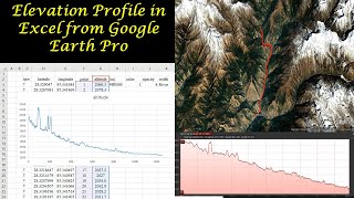
Remotely sensed elevation profiles can be generated using Google Earth Pro. This Google Earth Course will help you understand how to create a cross-section profile of the Earth's surface.
----------------------------------------------------------------
This tutorial answers the following questions
1. How to add a line feature
2. How to create an elevation profile
3. How to save a feature as kmz or kml
4. How to convert kmz file to txt file format
5. How to create a chart in Excel using altitude data from Google Earth Pro
----------------------------------------------------------------
You can also see…
Convert .kml and .kmz files to text files https://www.gpsvisualizer.com/elevation
How to add points, Lines and polygons to Google Earth Pro = • How to Create Point, Lines, Polygons ...
#googleearth #googlemaps
#gis
----------------------------------------------------------------
Want to reach me? Use the links in the About section of this channel
----------------------------------------------------------------