Published On May 10, 2022
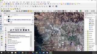
This video shows how to use the STAC API Browser Plugin in QGIS to search for Sentinel-2 or Landsat images for an AOI and load the images as Cloud Optimized GeoTiffs (COGs). We also cover how to create virtual rasters and clip them to create a mosaic. Finally, we save the result as a regular GeoTiff file on your computer that can be used for further analysis. The entire process leverages the cloud-native geospatial workflow, saving time and data transfer.
- 02:12 Search for Images over AOI
- 04:10 Load Individual Band COGs
- 05:40 Use 'Create Virtual Raster' to create a RGB composite as a VRT
- 08:14 Clip the VRT to the city boundary
- 09:30 Mosaic Clipped VRTs to a single VRT
- 10:30 Use 'Translate' tool to create a 10m resolution GeoTiff for the AOI
Learn more about
- Cloud Optimized GeoTiffs (COGs) https://www.cogeo.org/
- Spatial Temporal Asset Catalog (STAC) https://stacspec.org/
Watch videos from Cloud Native Geospatial Event
• Cloud-Native Geospatial Outreach Even...
Find more #QGIS learning resources at http://spatialthoughts.com/