Published On May 6, 2023
You can't always collect perfect images when flying your drone, so how do you improve them so that your photogrammetry models, orthomosaics and point clouds are as good as they possibly can be?
In this video we take a look at how you can use an image editing tool such as RawTherapee to adjust the shadows and highlights of your images so that you get the best result from your drone mapping. By applying these changes to your images, point clouds will be more accurate, additional details will be visible in your orthomosaic, models will align more accurately and the result will be vastly improved as well.
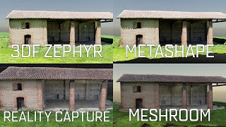
It does not matter if you process your data with Agisoft Metashape, Pix4D, DroneDeploy or something else, this method will work wonders for all of them.
https://rawtherapee.com/
How you can support my work
-------------------------------------------------
Please consider buying me a coffee:
https://www.buymeacoffee.com/geospati...
Hire me on Upwork:
https://www.upwork.com/freelancers/~0...
#rawtherapee #lightroom #photogrammetry