Published On Jun 2, 2024
Hi geospatial enthusiast!
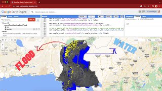
In this video, I would like to share a script to help you map flood events in a region for multiple years. I use the Sentinel-1 collection to map water masks in wet and dry seasons in a relational to make a flood mask. All the masks of flood masks are then aggregated to get the value of how often or frequently floods happen in a region which will become the flood hazard value.
Check the script: https://code.earthengine.google.com/b...
I hope this video can help you with your research and projects!
Email: [email protected]
Linkedin: / ramiqcom
GitHub: https://github.com/ramiqcom
show more