Published On Apr 25, 2024
Lake Calavera Loop is a 4.97-mile trail with 669 feet of elevation change and is part of Carlsbad Highlands Ecological Reserve located near Carlsbad, California. Standing at 513 feet (156 meters) tall, Cerro de la Calavera, also known as Mount Calavera, is an ancient plug dome volcano. Its last eruption occurred a whopping 22 million years ago!
Virtual / Extended Cut Video: • Calavera Lake and Cerro de la Calaver...
Blog Post: Coming Soon
==== My Gear & Support The Channel ====
Disclosure: Some of the links below are affiliate links, meaning, at no additional cost to you, I will earn a commission if you click through and make a purchase.
Buy anything from Amazon: https://amzn.to/3ymIprx
** Activity Tracking **
Garmin InReach: https://amzn.to/2SUFk1s
Garmin InReach Screen Protector: https://amzn.to/3v6GxBg
Garmin Instinct Watch : https://amzn.to/3yxo3vV
Garmin Instinct Watch Band: https://amzn.to/3ftpCSN
** Main Trail Camera Setup **
GoPro Hero7 Black: https://amzn.to/2T53zu4
GoPro Karma Grip x2: https://amzn.to/3wlDK7w
ND Filters (helps cut harsh light & improve video quality): https://amzn.to/3osPqCA
MicroSD: https://amzn.to/2ScUCP2
Chest Mount for Biking: https://amzn.to/3cLOkwX
Extension Cable for Biking: https://amzn.to/3zFoSTU
** Iphone Vlogging **
Iphone 12 Pro Max 256GB: https://amzn.to/2Ty4ByT
Iphone Stand: https://amzn.to/3wu9PKt
Iphone Tripod Mount: https://amzn.to/3ww5sij
Video Micro: https://amzn.to/3wGZrPC
** Studio Setup **
Main Camera (EOS R): https://amzn.to/3zuZQ9S
RF 15-35mm (lens): https://amzn.to/3vu8Rg3
Zoom H6 (audio): https://amzn.to/3pZUak0
Sennheiser MKE600 (mic): https://amzn.to/3gyI0eR
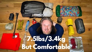
** Hiking Gear **
Water Bladder: https://amzn.to/3cKu9zC
Trecking Poles: https://amzn.to/3cKu9zC
Headlamp: https://amzn.to/2TB0j9S
Flashlight: https://amzn.to/3pXVLqd
First Aid Kit: https://amzn.to/3gC4TfZ
Knife: https://amzn.to/3q4Yq1t
Sunscreen: https://amzn.to/3iLbA1S
Paracord: https://amzn.to/35pdTzZ
Hiking Backpack: https://amzn.to/3xsAreW
** Connect with Me **
AllTrails: https://bit.ly/39ez9um
Instagram: https://bit.ly/2P7k8Un
Facebook: https://bit.ly/3soa1Jc
Twitter: https://bit.ly/3fqFCGT
Newsletter Signup: https://bit.ly/2Pt3pLj
Please Note: The Map Overlay, GPS Coordinates, Elevation Change are all custom coded and synced to the video. These values are approximations. I do my best to make them as accurate as possible, and hope to make it better overtime. You may notice some obvious mistakes, it happens... I hope you enjoy, it took A LOT of time to make with the help of several friends! :)
This is presented for informational use only. Please make sure to do your own research before attempting this adventure. While I try to present this information as accurate as possible, I may have missed important details (comment below if that is the case to help others out). I make no warranties on this information as the adventure details could change without notice.
Make sure to drop a comment below and let me know what trail you want to see next!