Published On Premiered Apr 28, 2021
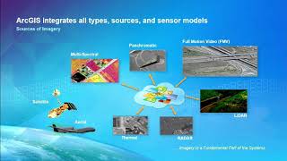
This video will teach you how to remove the No data area from the raster image or Landsat image in ArcGIS. Landsat images come with areas of no data which may not be of interest to you. they include borders, backgrounds, and any other data considered to not have valid values or black backgrounds. When doing image analysis, it’s important to remove this area of no data since they can affect your results.
show more